The Lost Medieval Villages of Nottinghamshire
- Posted in:
- Heritage
Scattered across the country are the traces of small medieval communities that disappeared from the countryside centuries ago. A deserted medieval village (DMV) refers to a settlement that was established during the medieval period in Europe, approximately between the 5th to 15th centuries AD, which has since been abandoned and left unoccupied. These were small, self-sufficient, agricultural communities, paying taxes to the feudal lords. Many of these sites are now protected as scheduled monuments.
In Nottinghamshire, LiDAR technology, aerial photography, historic records, and field survey, have so far revealed traces of 55 villages lost to time. Click here to discover their names and locations.
Have you ever seen a church in the middle of nowhere and wondered why it was built there? One local example is the ruined church of St James at Haughton. Check out the Church of St James record here.
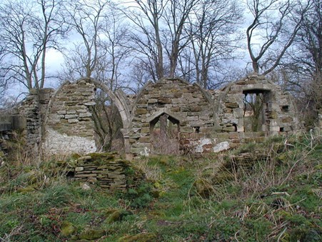
Above: Ruins of the Church of St James, Haughton.
These ruins are all that remain of the church and the only indication of the medieval village that was once here. First named as Hocton in the Domesday book, it was renamed Haughton in 1316. The early Norman church was restored in the C14th and served as the parish church. Check out the deserted village of Haughton record here.
During the Tudor period, common land that belonged to the people was claimed by noblemen and enclosed, with the villagers evicted. This was the fate of the medieval village at Houghton. In 1509, William Holles enclosed a park of 240 acres. He evicted the villagers, built Houghton Hall, and annexed the church as a domestic chapel. In 1691, Houghton Hall passed into the Holles family, but they preferred to live at Welbeck Abbey and left Houghton Hall and the church to fall into ruin. By 1790, records reveal that both buildings were ‘in total decay’. The Hall was demolished in 1770 and the upper parts of the chapel were reduced in the 1960s to the ruins visible today.
The site is visible in the LiDAR Survey of 2021. The outline of the church is clearly visible, but apart from a few sections of stone walling, there is little trace of the medieval village to be found today, in the surrounding arable landscape.
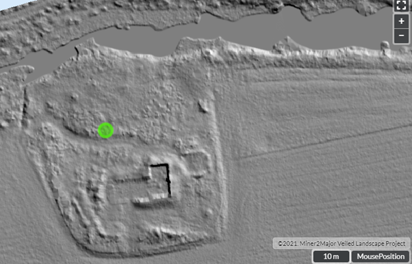
Above: LiDAR image of the deserted church at Haughton.
LiDAR images are a good source for identifying deserted medieval villages. Earthworks (trackways, ponds, ditches, boundaries, tofts and crofts and rigg and furrow) are often the only surviving signs of occupation, and they are easier to identify in LiDAR images than through field survey.
Enclosure was a common cause of the desertion of medieval villages. In some cases, it was necessary due to changing cultivation practices at a time when sheep farming was more profitable than agriculture. This is known to be the reason for the desertion of Thorpe in the Glebe. Other reasons for population decline and desertion include famine, disease and conflict. Urbanisation was also attracting some people to migrate to towns and cities. Check out the Thorpe in the Glebe deserted Medieval village record here.
Some impacted villages did survive. Today, the village of Little Carlton near Newark, is a linear settlement, with houses built along Bathley Lane. In medieval times, the populated area was further west, close to the manor house. Today this area is farmland, but the marking of medieval trackways, sunken pathways, boundaries, house platforms, tofts, and a pond are still visible. Little Carlton is an example of a village that has either shrunk over time or shifted its central point. Check out the shrunken village of Little Carlton record here.
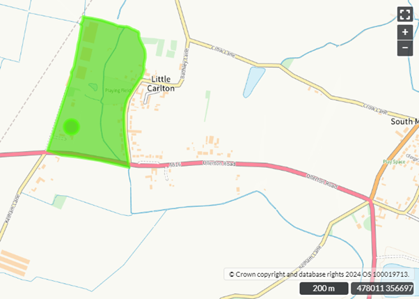
Above: The area marked in green shows the scheduled site of the shrunken village of Little Carlton.
Through the combination of modern technology and historical texts, the long-gone villages of medieval Nottinghamshire are re-emerging. Pioneering archaeological techniques might yet tell us more about their demise. At a site featured on Digging for Britain, Tephra particles were identified in soil samples taken from the deserted medieval village of East Hestlerton, in Yorkshire. This is the first direct evidence that volcanic activity in Iceland, may have caused crop failures in England in the sixth century, and perhaps resulted in the demise of some medieval villages. Could this be the case in Nottinghamshire too?