‘This road was built by the Romans, see how straight it is!’

A phrase said by many-a-parent to their kids on long road trips as an attempt delay the inevitable ‘are we nearly there yet’ question. If you are anything like me, you’d peer out of the car window in wonder, watching the hedgerows and signposts swoosh past, trying to imagine instead a scene filled with Roman soldiers in bright lorica segmentata armour and banners fluttering in the breeze.

Some of these great highways built by the Romans became so embedded in our later infrastructure that they are major highways nearly 2000 years later. The A46 Fosse Way, which runs askew through Nottinghamshire from Gallows Nooking in the east to Broughton Lodge in the south, is one such road. Laid and re-laid, tweaked, and re-routed over the centuries to the point where in places the modern route has been altered entirely to avoid and protect Roman towns, like Margidunum.

When you see a long straight road on a map you may wonder ‘was that built by the Romans?', but how do we find out if that was the case? For some roads it is pretty straightforward. Many of our well-known Roman roads, like the Fosse Way and the road from Lindum (Lincoln) to Danum (Doncaster), are detailed in the Roman versions of road maps called ‘itineraries’. These aren’t maps in the same way we imagine them, but rather lists of places you will find along certain roads and the distance between them. This is how we can know the names of some of the deserted towns like Segelocum (Littleborough) and Crococalana (Brough).

Map of the Roman road stretching from Kirklington to Bilsthorpe

Above: Map of the Roman road stretching from Bilsthorpe to Kirklington.

But the Romans built more roads than we have itineraries for, so how can we spot the rest?

The problem with identifying Roman roads is that they were built a long time ago and nearly 2000 years has since intervened. Some routes went out of use as soon as the army didn’t need them in the early years after invasion, others when the Roman infrastructure broke down as Rome abandoned the province. Others remained in-use as long-distance highways that didn’t necessarily link places where people lived but were useful for getting around. The A46 in Nottinghamshire is a good example of this. In some cases a Roman town persisted, such as Lincoln, and the Roman roads became embedded in the later settlement structure.

People try to spot Roman roads by looking for straight ones, but they aren’t all ruler-straight, especially after 2000 years. The Romans were efficient with their road building, but not stupid, and would squiggle to avoid some things and to course-correct. If the road survived, with only sporadic local maintenance, it might wander across the landscape as it ebbed and flowed with use, much like the meandering of a river.

There are plenty of red-herrings too! Enclosure of common land, following the 1750 enclosure acts, led to the creation of new roads which were also straight and broad and often with many boundaries and roads at right-angles to them. So, there are subtle clues you have to look for to decide whether you’re likely looking at a Roman road or an enclosure one.

Without digging and finding the Roman road surface, we have to go on the ‘balance of evidence’. Does it link places of significance in Roman times? Does it appear to pre-date the other boundaries in the area? Even where we know that we are looking at a Roman road such as the A46, it was very rare that the recent dualling work uncovered anything that looked like the original road surface.

The reality is that some routes that we use today may be very old indeed, while others exist only as the ghosts of trackways appearing as cropmarks in fields. For most of them their origins will remain elusive until we have more evidence that we can piece together.

Miner2Major is a Landscape Partnership scheme supported by the National Lottery Heritage Fund. It encourages local communities to get involved in projects that celebrate the diverse wildlife, important habitats, and rich heritage of Sherwood Forest. A significant aspect of the heritage is the role this area played during World War I. 

WW1 Clipstone Camp Monument record MNT27602

Miners working on the Nottingham coalfield were quick to volunteer to join Lord Kitchener's New Army in August 1914. In fact, within the first month, 300 local men, mostly miners, had enlisted at Mansfield into the Sherwood Foresters Battalion, which forced the newly opened Clipstone Colliery to close (Marples, 2013, pp. 11-12).

Across the country, more than 2.5 million men answered the call. The Duke of Portland offered his land for military use and a new training camp was built. Clipstone Camp became the largest training facility in the country, housing between 20,000 and 30,000 soldiers at a time between 1915 and 1921. Soldiers from all over the country trained at Clipstone.

Map of Clipstone Camp

Above: The site of Clipstone Camp. The green areas mark the northern and southern lines of the WW1 Camp.

The camp was built on the open heathland in the area between Clipstone Drive and Mansfield Road. The wooden huts were organised in lines to accommodate whole battalions. Training exercises took place in the surrounding countryside, which includes areas now known as Sherwood Pines Forest Park, Vicar Water Country Park, and Strawberry Hill Wood. Some remnants of trenches and rifle ranges can still be seen in these areas today. As the camp grew, more facilities were added, including a hospital, a railway, churches, and a theatre. The hospital received wounded soldiers evacuated from the battlefields. Of those who sadly died there, 28 soldiers and one nurse are buried in St Alban’s churchyard in Forest Town.

WW1 Clipstone Camp plan over current mapping

Above: The WW1 Clipstone Camp plan (War Office, 1915) over current mapping (insightmapping 2023, Nottingham City Council).

The local communities of Forest Town and Mansfield welcomed the soldiers and offered their hospitality. In return, the camp held public open days, giving visitors a glimpse into the lives of their loved ones serving overseas. A highlight was the tour of the hut gardens, which were carefully created and maintained by the soldiers. The soldiers also enjoyed tours of the mine, swimming in Vicars Water and joint sporting and musical events. Local women were keen to do their bit by volunteering in the camp as nurses, maids, and caterers.

After the war, the camp became a demobilisation centre, with the last men leaving in 1921. The huts and equipment were sold at public auctions and many huts were purchased for housing and community use. Some were kept for use by the colliery village when it reopened in 1920. The Church hut remained in use by community groups until the 1950s.

The huts and parade grounds of the former camp were overlaid by new colliery housing in the 1920s. Many of the roads still follow the original lines of the camp. Today, apart from memorials at the Social Club and Vicars Water, there are few reminders of the impact of World War I on this small Nottinghamshire community.

Suggested reading:

Miner2Major Logo Baner

www.miner2major.org.uk

Follow the project: Instagram | Twitter | Facebook

Strawberry Hill is a Nottinghamshire Wildlife Trust (NWT) nature reserve, and up until recently, records within the nature reserve and surrounding area were scarce, with no recorded archaeological work having been carried out on site before. The scarcity of records is likely a result of the extensive mineral extraction activities which were carried out before archaeological considerations were drawn into the planning process. There is a wealth of documentary evidence that indicates Strawberry Hill was once a significant landscape feature and way-marker.

Strawberry Hill has been a significant feature in the landscape since Medieval times and it appears, under different names, on numerous historic maps as well as Medieval perambulation documents. It sits on the historic boundary between the land of the abbots of Rufford and the land of the King’s manor of Mansfield. 

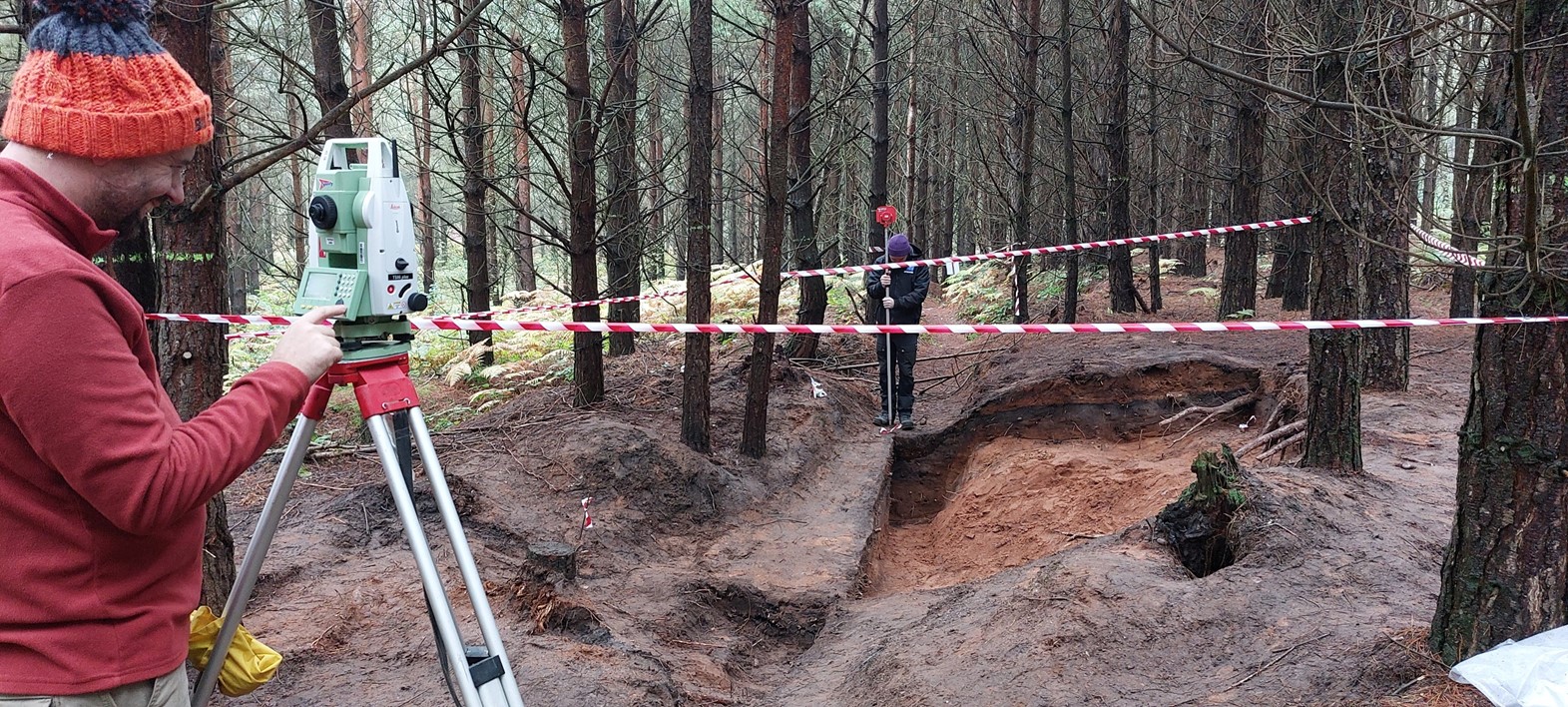
Recently, as part of the Miner 2 Major Veiled Landscape project, the area was subject to an archaeological survey, where NWT volunteers and a Nottinghamshire County Council archaeologist used lidar data to help guide the on-the-ground recording of previously unrecorded archaeological features. This survey enhanced our knowledge of the presence and significance of archaeological features and resources within the woodland.

LiDAR image showing earthworks within Strawberry Hill Nature Reserve

Above: LiDAR model showing earthworks within Strawberry Hill Nature reserve.

Several hollow ways survive within the woodland, one set of which is a well-used Medieval routeway that went out of use some time in the post-Medieval period. These are sections of deeply eroded ‘U’ shaped hollow ways that almost certainly represent a Medieval routeway between Mansfield and Bilsthorpe, which passes by Inkersall on the north side of the dam. This appears on the 1637 map of the Rufford Estate drawn by Bunting. Given the significance of the hill here in the landscape, historically it is possible that some of the other recorded hollow-ways may have significant age to them.

NWT volunteers and Nottinghamshire County Council archaeologist Emily Gillott standing in the contours of the Medieval hollow way

Above: Nottinghamshire Wildlife Trust volunteers and Nottinghamshire County Council archaeologist Emily Gillott standing in the contours of the Medieval hollow way.

There is also a well-preserved set of practice trenches from army training activities from the earlier 20th century This is part of a wider landscape that is characteristic of this part of Nottinghamshire, as many of the large estates turned over some of their land to military usage.  Many classic features of the trench warfare system are apparent including the classic zig-zag plan and communication lines dug to connect parallel trench sets. 

You can explore these records and the lidar survey data by searching in the database for the records below:

You can learn more information about the Veiled Landscape Project and the application of lidar here: The Veiled Landscape: Sherwood Lidar Project - Nottinghamshire Historic Environment Record

Gallows and gibbets are popular imagery in historical fiction for portraying the brutal horror of justice in bygone eras (though people of my age and younger may be shocked to learn that the last hangings in the UK were carried out as late as 1964). Gallows frequently appear in film and media, but gibbets are less-commonly depicted and popularly understood.

Hanging, along with beheading, were common methods of carrying out capital punishment for centuries in Europe. In certain cases where crime was considered especially heinous (murder, treason, robbing a mail cart), the body may be left to hang on the gallows, or the punishment may extend to the body being ‘hung in chains’ and transferred to a gibbet.

A gibbet was a tall wooden post set into the ground, with a crossbar at the top from which hung a cage made of iron. Often the wooden parts would be reinforced with metal bands or nails to prevent vandalism. The cage itself may have looked a bit like a large bird cage, but in the post-Medieval period it was more likely to be a custom-made thing, designed to fit the body of the deceased and keep them looking human-shaped as long as possible. The body of the accused may be left for days, months or years. A grisly trade grew up around collecting parts of the decaying corpse for use in medicine and charms.

The aim of gibbeting was to display a kind of macabre earthly purgatory; the body was kept suspended between the Earth and God, occupying a liminal boundary between life and death. In order to serve their ghastly purposes as deterrents they were often erected in highly visible locations, such as by main highways, on prominent hills, or at crossroads. Sometimes they were located close to the scene of the associated crime, or (more brutally) close to the residence of the condemned person’s family. Accessibility had to be a consideration too as the gibbet would draw visitors for months or years after their placement.

In 1752, the Murder Act codified the treatment that the bodies of murderers legally had to undergo before they could be buried; anatomical dissection or hanging in chains. By far the most common treatment was dissection as the ‘enlightened’ minds of the Age of Reason made use of the corpses for study. By comparison, hanging in chains happened only a small handful of times a year nationally by this time but drew huge crowds whenever it did.

Gibbeting was meant as a gruesome warning against disobedience; an authoritarian attempt to coerce compliance. The reality in many cases, however, was that gibbeting secured the fame, or rather infamy, of the condemned especially where it was perceived that there had been a miscarriage of justice or where the extreme punishment outweighed the crime.

Photo of the Church of St Wilfred in Scrooby

Above: The Church of St Wilfred in Scrooby. The Church resides close to reported gallows in the area.

The Historic Environment Record contains a few references to gallows and gibbets for Nottinghamshire. Gallows Nooking is found where the A46 Fosse Way leaves/enters Nottinghamshire on the east. According to the antiquarian William Stukeley, the gallows were situated atop a mound built into the middle of the roadway. Similarly,‘Galow tre hyl’ in Thieves Wood off the A60 approaching Mansfield, depicted on a late 14th/early 15th century map, was raised on a mound with the old road curving around it to afford the traveller panoramic view. Gibbets are recorded at Scrooby on the Great North Road, and at Shelford on a high eminence above the Trent, both atop custom built mounds.

There was no missing the message if you were a traveller on these roads; behave or be hung.

This coming week will be very exciting for heritage lovers in Nottinghamshire with the return of Heritage Open Days’ annual community festival!

Photograph of Newark Castle

The festival, which has been running for over 25 years in the UK, provides individuals with the chance to get involved in heritage through exclusive local events. This festival contributes to the European Heritage Days in which 50 signatory states celebrate diversity, culture, and heritage every September.

Heritage Open Days aims to celebrate heritage and community by organising talks, workshops, and tours of historical sites. All the events in this festival are free. This includes rare visits to selected sites that normally ask for an entry fee. For example, usually closed on Sundays, the DH Lawrence Birthplace Museum will be opening its doors to the public, for free, on Sunday 10th September. Other sites included in this festival are Newstead Abbey, Bromley House Library, and The Workhouse and Infirmary. Visit the Heritage Open Days website for the full list.

Running from Friday 8th September until Sunday 17th September, there are over 70 exciting events happening in the Nottinghamshire area.

A member of our Historic Buildings team, Jason, will be running behind the scenes tours of the Walks of Life Museum in Newark. Come and say hello to him on Friday 15th September! Visit the event page for information here: Walks of Life Museum - Carts Inspire Creativity

Here are some of the other events we’re excited about:

  • Focusing on ten amazing artefacts, join the Manuscripts and Special Collections team at the University of Nottingham for a talk on how their amazing items reflect the significant people, places, and events in Nottingham’s history. There will be 2 identical talks on Friday 15th September (booking required). See the event and booking information here: University of Nottingham - Archives Unwrapped Talk: Nottinghamshire's History in Ten Treasures
  • In partnership with Polish Village, Newark Castle has organised a fun day of activities for the family on the castle grounds. Enjoy exploring the castle towers, making Polish eco-friendly crafts, face-painting, and listening to fantastic tales by a storyteller. This Creativity Unwrapped event is due to take place on Saturday 9th September (no booking required). See the event information here: Newark Castle - Creativity Unwrapped
  • Take a behind the scenes tour of the Nottinghamshire Archives’ storage areas and conservation studio. Learn about the archives and how to maintain them like an expert on Tuesday 12th and Thursday 14th September (booking required). See the event and booking information here: Inspire -  Nottinghamshire Archive Behind the Scenes Tours
  • Exploring the rich history and heritage secrets of Nottingham, two guided tours have been organised by local experts of Mansfield and Beeston town centres. A member of the Mansfield Townscape Project will be leading a guided tour Mansfield town centre on Wednesday 13th September (no booking required) and on Sunday 10th September, Professor John Beckett will be performing a tour around central Beeston (booking preferred). See event information for the Mansfield town tour here: Mansfield Town Centre Heritage Walk. See event and booking information for the Beeston tour here: Walk with an Expert: Heritage Beeston
  • Come and enjoy author Sally Mitchell’s exciting presentation on the dangers women faced when riding side saddle and some of the famous ladies who experienced them. Sally will also be showing many interesting costumes and items alongside a tour of the collection at the Museum of the Horse in Tuxford on Thursday 14th September (booking required). See the event and booking information here: Museum of the Horse - The Dangers of Side Saddle!

To find out about all the events being offered in Nottinghamshire, including dates and booking information, please visit: Heritage Open Days

Please be aware that free entry to some sites is only on specific set days and some events may require booking.